Dubai Metro Map — Interactive Network Map
Download the Dubai Metro Map
Save the Dubai metro map to your phone before you travel. A stored image opens instantly, costs no roaming data, and stays readable when you are standing on a platform working out which way the next train goes. It is also the version to print if you would rather carry paper than unlock a screen each time.
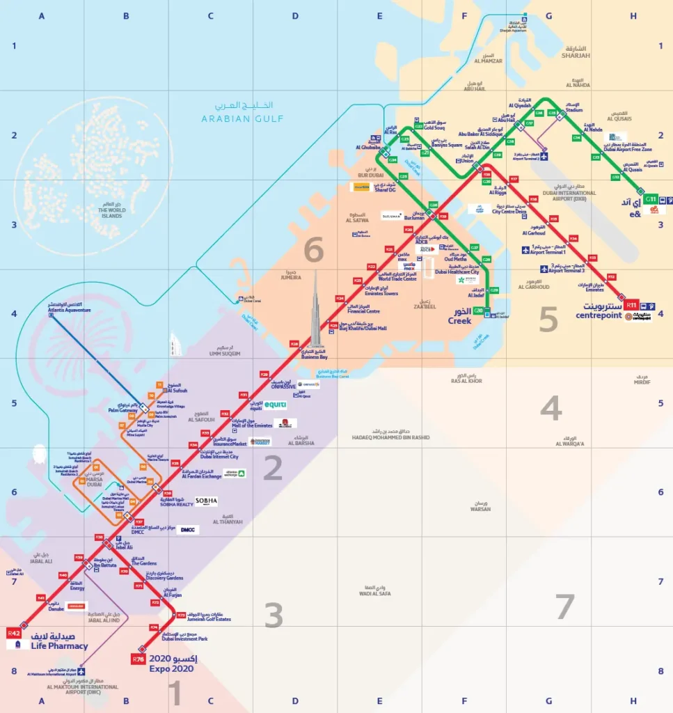
Dubai Metro network map
↓ Download zone mapEvery station on both operating lines, plus the Route 2020 branch, drawn over the real street layout so you can see which part of the city each stop actually sits in. For RTA's own PDF, see rta.ae.
How to Read the Dubai Metro Map
Six conventions carry almost all the information on the map.
- Line colour. Red and green are the two operating lines, and they are the only two the map draws — a Blue Line is under construction but carries no passengers yet, so it does not appear.
- Station codes. The letter gives the line and the number gives the position along it: the Red Line runs R11 to R42, the Green Line G11 to G30. Numbers are not consecutive — gaps are reserved for stations not yet built.
- Interchanges. A station carrying two badges is where you can change lines without leaving the paid area. There are exactly two: Union (R18 / G20) and BurJuman (R19 / G26).
- The Route 2020 branch. South of Jabal Ali (R38) the Red Line splits. One arm continues to UAE Exchange, also signed as Life Pharmacy (R42); the other runs R70–R76 to Expo 2020. Trains alternate between the arms, so check the destination on the front of the train rather than assuming any Red Line service goes your way.
- Zones. The large grey numerals 1–7 on the zone map are geographic areas, not fare prices. What you pay depends on how many zone boundaries you cross, not how far you ride — a long trip inside one zone can cost less than a short hop across a boundary.
- Orange markers and aircraft icons. Orange flags a Dubai Tram interchange (Sobha Realty R36 and DMCC R37); the small aeroplane marks the airport terminal stations, Terminal 1 (R14) and Terminal 3 (R13).
Dubai Metro Lines at a Glance
Fifty-three stations in total. Union and BurJuman are counted once each but appear on both lines, which is why the individual line totals add up to more.
Red Line
- Stations
- 35, including the Route 2020 branch
- Terminals
- Centrepoint (R11) · UAE Exchange / Life Pharmacy (R42) · Expo 2020 (R76)
- Interchanges
- Union, BurJuman
Green Line
- Stations
- 20
- Terminals
- Etisalat by e& (G11) · Creek (G30)
- Interchanges
- Union, BurJuman
Route 2020
- Stations
- 6 (R70–R76)
- Branches at
- Jabal Ali (R38)
- Terminal
- Expo 2020 / Expo City
Change between lines at Union or BurJuman — no need to tap out and back in, as the transfer sits inside a single journey fare. A Blue Line is under construction and is expected to link Creek and Centrepoint with Academic City and International City; it does not carry passengers yet and is absent from the zone map.
Frequently Asked Questions
Is there an official RTA PDF of the Dubai Metro map?
Yes — RTA publishes the authoritative network map on rta.ae, and printed copies are displayed inside every station concourse. The file above is an image rather than a PDF: it opens faster on a phone and stays legible when you pinch to zoom, which a multi-megabyte PDF often does not. Treat RTA as the final word on any change to names, fares, or opening dates.
How many stations does the Dubai Metro have?
Fifty-three in service. The Red Line accounts for 35 of them once the six Route 2020 stations are included, and the Green Line for 20. Those figures overlap by two, because Union and BurJuman are shared interchanges that belong to both lines.
Can I use the downloaded map offline?
Yes. It is an ordinary image file, so once saved it opens from your photo library or downloads folder with no connection at all — useful if you are on an expensive roaming plan or simply want the network in front of you without waiting for a page to load. It prints legibly at A4, though A3 is worth it if you want to read the smaller station labels comfortably.
Which stations connect the Red Line and the Green Line?
How do the zones on the map affect my fare?
Dubai is divided into seven zones, shown as the large grey numerals on the zone map. Your fare is set by the number of zone boundaries your journey crosses — one zone, two zones, or three and above — not by the distance travelled. It is worth checking the boundary before a short trip, since crossing one costs more than a much longer ride that stays put. Our fare calculator works this out between any two stations.
Does the map show the Blue Line?
No. It shows only the network carrying passengers today, which is the Red Line, the Green Line and the Route 2020 branch. The Blue Line is still under construction, so no station on it can be used yet and its final station names may change before it opens.